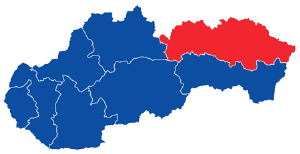
The capital of the region is city Prešov, according to the population the third largest city in Slovakia. Region Presov has area 8972,89 km2. Region is situated in the west - east. It fills the northeastern part of Slovakia (it is the eastern regions of Slovakia). Region has common borders with two states, Poland, Ukraine and three Slovak Regions - Region Košice (Košický kraj), Region Banska Bystrica (Banskobystrický kraj) and Region Žilina (Žilinský kraj).
The territory of the region has mostly mountainous character. The region covers the subdivisions of mountains - High Tatras (Vysoké Tatry) and Belianske Tatras (Belianske Tatry) The territory also covers mountains and highlands - Šariš highland, Ľubovnianska highlands (Ľubovnianska vrchovina), Čergov, Ondavská Highlands (Ondavská vrchovina), Slanské Hills (Slanské vrchy), Pieniny, Levoča Mountains (Levočské vrchy), Laborec Highlands (Laborecká vrchovina), Bukovec Mountains (Bukovské vrchy), Vihorlat Mountains (Vihorlatské vrchy). Part of the Eastern Slovak Lowland (Východoslovenská nížina) extends here.
There are national parks - Low Tatras National Park (Národný park Nízke Tatry), Poloniny National Park (Národný park Poloniny), Slovak Paradise National Park (Národný park Slovenský raj), Pieniny National Park (Pieninský národný park) in Region Presov. There extends also Tatra National park (Tatranský národný park) on the territory of region.Attractions, Districts, Cities - Municipalities, Nature protection, Protection of Monuments, Nature
